Travelers reaching the Bac Quang crossroads often face a confusing choice: negotiate a high-priced private car or try to locate the unmarked local shuttle bound for Vinh Quang. Getting to Vietnam's most spectacular terraced fields is a logistical puzzle that catches many independent hikers off guard. This guide removes the guesswork.
Hoang Su Phi is a mountainous district situated in the western part of Ha Giang Province in Northeast Vietnam, sharing a 41.421 km border with China. The district lies approximately 310 kilometers northwest of Hanoi and relies heavily on its manual agricultural output. Elevations vary drastically from 500 meters in the valley floors to over 2,400 meters at the peaks.
This topography creates steep, rugged terrain covered in extensive agricultural terraces carved directly into the hillsides over centuries. Accessing specific communes requires navigating distinct geographic pockets, each varying in altitude and road quality.
.jpg)
| Commune | Altitude | Primary ethnic minority | Average travel time from Vinh Quang | Trekking access difficulty |
|---|---|---|---|---|
| Ban Phung | 1,200m | La Chi | 1.5 hours | Advanced |
| Ban Luoc | 1,000m | Dao, Tay | 1 hour | Moderate |
| Ho Thau | 1,500m | Red Dao | 2 hours | Advanced |
| Thong Nguyen | 800m | Red Dao | 45 minutes | Easy |
| Nam Ty | 900m | Red Dao | 1 hour | Moderate |
.jpg)
The optimal period to observe the yellow rice harvest in Hoang Su Phi is from mid-September to early October. During this annual window, the terraced fields across communes such as Ban Phung and Ban Luoc turn golden before local farmers begin the manual harvesting process.
Because the district covers varying elevations, rice ripens at different rates. Valleys around Nam Ty harvest first, usually by September 20, while the higher terraces of Ban Phung delay cutting until the first week of October. Plan your dates based on the specific route you intend to hike.
.jpg)
Travelers typically board a sleeper bus or private limousine from My Dinh bus station in Hanoi to Tan Quang junction on National Route 2, a journey of roughly 240 kilometers. Tickets cost around 300,000 VND ($11.80). From Tan Quang, local buses, motorbikes, or private transfers cover the remaining 58 kilometers of winding mountain roads to Vinh Quang town.
The switchbacks force drivers to maintain low gears, slowing average speeds down to 25 kilometers per hour. Anticipate a total transit time of eight hours from the capital before reaching your final homestay.

.jpg)
📌 Insider note:
Rent a Honda Wave from QT Motorbikes in Ha Giang City for 150,000 VND ($5.90) per day rather than risking an untested rental from Sapa. The DT177 route connecting Tan Quang to Hoang Su Phi requires functional brakes. During the July to August rainy season, this specific mountain pass suffers from spontaneous mudslides, often trapping riders between collapsed cliff faces for hours.
.jpg)
Yes, foreign visitors traveling in Ha Giang Province, including Hoang Su Phi, must obtain a provincial entry permit. This document is issued by the Ha Giang Immigration Office in Ha Giang City for a standard fee of 210,000 VND, equivalent to approximately $8.25.
Without this physical stamp, homestays in border-adjacent communes will turn you away. Police conduct sporadic checks on guesthouse ledgers, and property owners face steep fines for hosting unregistered foreigners.
.jpg)
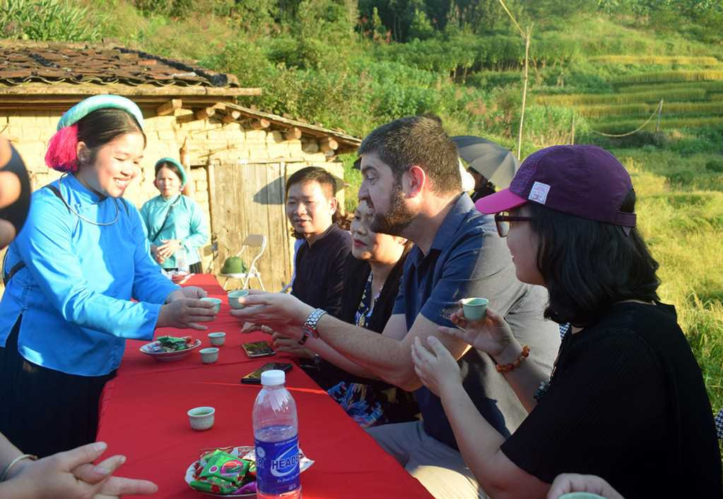
Hoang Su Phi is inhabited by twelve distinct ethnic minority groups, with the Red Dao, Flower Hmong, Tay, Nung, and La Chi comprising the majority of the population. These communities maintain traditional agricultural practices and manage the recognized national heritage terraced fields across the district.
You find the Red Dao mostly around the Thong Nguyen area, recognizable by their heavy silver jewelry and bright red headdresses. The La Chi reside predominantly in Ban Phung, constructing their wooden houses on stilts directly over the cascading rice paddies.
.jpg)
.jpg)
📌 Insider note:
Always ask for verbal consent before raising your lens at farmers cutting rice in the terraces. Keep drones packed away; flying near the porous Chinese border triggers immediate police confiscation. During dinner, hosts often pour shots of Nang Don rice alcohol to accompany a Thang Co meat stew. If you reach your limit, tap your index finger twice on the table to respectfully decline further pours.
Hoang Su Phi offers some of the most punishing gradients in Northern Vietnam. Hikers skip the paved roads for narrow dirt trails cutting straight through primary forests and steep agricultural zones.
| Peak | Elevation in meters | Distance from district capital | Trekking duration | Key highlights |
|---|---|---|---|---|
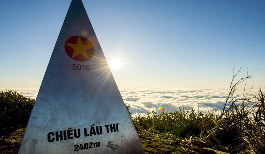
| Chieu Lau Thi | 2,402m | 42km | 2 days | Mossy forests, sweeping summit views over Ha Giang |
| Tay Con Linh | 2,428m | 46km | 3 days | Ancient tea trees, sacred La Chi grounds, extreme gradients |
.jpg)
The La Chi people consider the Tay Con Linh mountain range the residence of their ancestral spirits. Do not yell or blast music on portable speakers when traversing these forests. If you tackle the 42-kilometer approach to the 2,402-meter Chieu Lau Thi summit, carry extra fuel. The 15 percent road grades burn through a standard tank of petrol long before you reach the upper base camp.
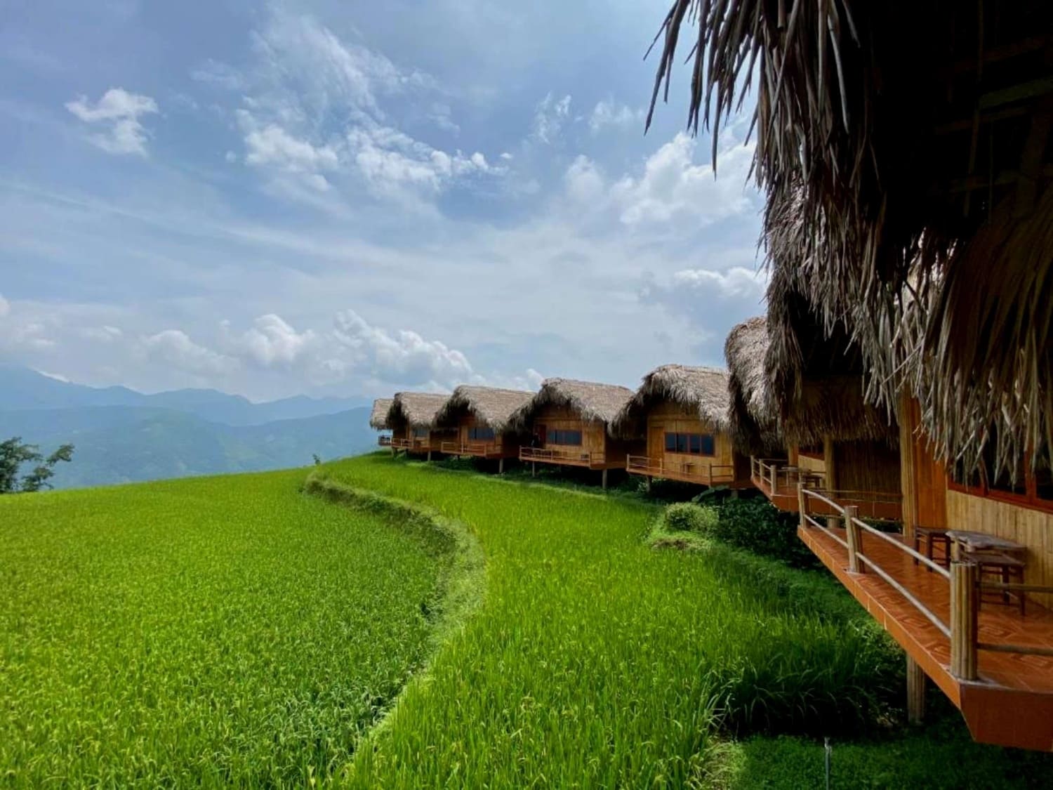
Book the Hoang Su Phi Lodge or Panhou Retreat located in Nam Hong village for a high-end recovery after days of trekking. These properties sit at the exact geographic convergence of three mountain streams. Ask the lodge staff to brew a pot of local Shan Tuyet tea, sourced directly from ancient, moss-covered trees growing above the property at 1,300 meters.
.jpg)
CTA TA
Vinh Quang town operates three reliable ATMs, including an Agribank branch on the main street. However, machines frequently run out of cash during the September harvest festival. Withdraw at least 3,000,000 VND ($118) in Hanoi before departing, as remote homestays in Ban Phung operate strictly on cash.
Trekking here requires high cardiovascular fitness. The gradient between Thong Nguyen and Nam Ty frequently exceeds 15 percent, forcing hikers up unpaved, mud-slicked paths. You cover an average of 12 to 15 kilometers daily with elevation gains of 800 meters, making it significantly harder than standard Sapa routes.
Hoang Su Phi delivers a quieter experience with sharper, towering terraces built by the La Chi people up to 1,500 meters. Mu Cang Chai features broader, more accessible valleys alongside National Highway 32. Choose Hoang Su Phi for isolation, and Mu Cang Chai for roadside photography and easier transport.
A Ban Luoc farmer wakes at 4:30 AM to feed livestock before walking up to three kilometers to the upper terraces. By September, activities shift to manual harvesting using handheld sickles. The afternoon involves threshing rice on wooden tarps, bundling stalks, and repairing mud irrigation channels before sunset.
Sunday markets in Vinh Quang serve heavy, calorie-dense highland food. You find steaming bowls of Thang Co, a horse meat soup heavily spiced with cardamom and lemongrass, selling for 50,000 VND ($1.95). Stalls also prepare black pork skewers, sticky rice wrapped in banana leaves, and fried corn cakes.
Best visited during dry season (November to April) for ideal weather.
Book accommodations in advance during peak travel season.
Carry local currency (Vietnamese Dong) for markets and small vendors.
Respect local customs and dress modestly when visiting temples.