Everyone is packing into crowded Sapa, completely missing Vietnam's ultimate wild frontier right next door. But let's be real: navigating Cao Bang takes serious guts and planning. You are dealing with strict military border rules, sudden digital dead zones where Google Maps dies, and rugged mountain logistics. If you think a basic bus ticket is enough, think again
Yes, Cao Bang is absolutely worth visiting. Often called North Vietnam's finest remote territory, it offers massive border waterfalls, unique karst caverns, rich ethnic minority culture, and profound historical sites within a UNESCO Global Geopark, all without the overwhelming crowds of Sapa.
You will encounter a region largely untouched by mass tourism development. The local economy relies heavily on agriculture and traditional crafts rather than souvenir stalls, ensuring authentic interactions with the Tay, Nung, and Dao ethnic groups. Accommodations range from basic rural homestays to comfortable eco-lodges, providing necessary amenities without ruining the raw environment.
%20(1).jpg)
Furthermore, the geographical diversity keeps daily itineraries highly varied. You can spend the morning hiking through extensive underground river systems and the afternoon riding a motorbike across expansive, grassy valleys. For travelers seeking an unfiltered view of provincial Vietnam, this province delivers exceptional value and solitude.
Cao Bang is located about 270 to 280 kilometers northeast of Hanoi. The journey takes approximately 6 to 9 hours by road, depending on whether you take a sleeper bus, limousine van, or travel by private motorbike.
.jpg)
Most travelers depart from Hanoi's My Dinh Bus Station. Highway QL3 serves as the primary artery connecting the capital to the northern borderlands. While the road is fully paved and generally well-maintained, the final 100 kilometers feature sharp switchbacks, steep inclines, and heavy commercial truck traffic heading to the border.
| Criteria | Sleeper bus & Limousine van | Motorbike & Easy rider |
|---|---|---|
| Time required | 6-9 hours | 2-3 days (multi-stop route) |
| Estimated cost | $12.00 - $24.00 | $15.00/day (DIY) - $90.00/day (Guided) |
| Pros / Cons | Pros: Safe, cheap, allows rest. Cons: Cramped sleeper cabins, limited schedules. | Pros: Total freedom. Cons: High danger on QL3, unpredictable mountain weather. |
When booking transit online using platforms like 12Go Asia, ensure you search specifically for Ha Giang City connections if you plan to link this trip with the northeast loop. Many transport operators run direct mini-buses between these two northern hubs, eliminating the need to return to Hanoi first.
.jpg)
Self-driving motorbikes grant access to deep remote exploration, allowing you to stop at unmarked viewpoints. However, hiring an Easy Rider remains the absolute safest option for tackling steep, gravel mountain paths. These local guides understand blind corners, horn-signaling etiquette, and weather patterns better than any foreign rider.
The best time to visit Cao Bang is during the dry season from October to April. This window is ideal for exploring waterfalls, hiking caves, and riding through the UNESCO Geopark without the disruption of heavy rains or flooded roads.
During these dry months, specific geographical features transform entirely. The valley floor surrounding Angel Eye Mountain becomes a sprawling, grassy pasture. You can set up tents for wild glamping and ride motorbikes directly across the dry plains. Temperatures do drop significantly between December and February, requiring thick thermal layers for evening riding and unheated homestays.
.jpg)
Conversely, wet season travel demands extreme caution and flexibility. From June to August, those same grassy valley floors can rapidly flood into deep lakes, completely submerging the access roads. Mountain passes regularly suffer from sudden landslides, rendering them dangerously slippery and sometimes impassable for two-wheeled transport.
.jpg)
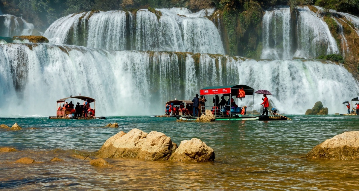
The top attractions in Cao Bang include the majestic Ban Gioc Waterfall, the towering stalactites of Nguom Ngao Cave, the historical Pac Bo site, and the striking geography of Thang Hen Lake and Angel Eye Mountain.
📌 Expert Insight:
International visitors should time their visit between 10:00 AM and 1:00 PM when the upstream hydro dam opens. This guarantees maximum water flow cascading over the 300m wide falls.
Straddling the border between Vietnam and China, this cascading giant serves as the region's primary draw. Standard entry costs roughly 40,000 VND ($1.60) at the main ticket booth. Once inside the perimeter, you can hire a traditional bamboo raft for an extra 50,000 VND ($2.00) to float directly into the heavy mist near the base.
The Vietnamese side retains a much rawer nature experience compared to the heavily developed Chinese side. The opposite riverbank features massive concrete viewing platforms and commercial infrastructure. You will clearly see foreign tourists on their own rafts floating just meters away across the invisible demarcation line.
%20(1).jpg)
📌 Expert Insight:
Western tourists cannot cross into China via the new Joint Tourism Zone without a pre-arranged Chinese Visa and formal checkpoint clearance. Additionally, flying drones here is strictly forbidden due to military sensitivity.
Located just a few kilometers from the waterfall, this massive limestone cavern stretches deep into the mountain. Do not settle for the standard 20-minute walking circuit near the entrance. Instead, opt for the long route, costing approximately 200,000 VND ($8.00) at the ticket counter.
This extended tour includes a mandatory private guide who leads you deep into unlit chambers. You will don a headlamp, wade through shallow subterranean waters, and take a fascinating boat trip through an underground river system. Wear shoes with heavy traction, as the cave floor remains wet and slick year-round.
.jpg)
This natural phenomenon features a massive circular hole passing completely through the peak, surrounded by sharp, shark-tooth karst formations. The visual impact is striking, especially during early morning hours when sunlight punches directly through the rock aperture.
Reaching the site requires traversing unpaved agricultural tracks. The final two-kilometer approach is extremely steep, rocky, and deeply rutted by local tractor tires. Novice riders should proceed with extreme caution or simply park early and walk the remaining distance to the valley floor.
.jpg)
This heavily forested area serves as a site of immense national pride for the Vietnamese people. Ho Chi Minh secretly lived here in a small cave after returning to the country in 1941 to plan the independence movement. The area features pristine, sapphire-tinted waters that are highly photogenic against the dense jungle backdrop.
To navigate the expansive grounds efficiently, pay the 30,000 VND ($1.20) fee for the electric shuttle bus. This saves you from a long, exhausting walk in the humid heat from the parking lot to the main historical markers. Note that swimming in the sacred stream is strictly prohibited by park authorities.
.jpg)
Driving along Highway QL3, you will hear the rhythmic clanging of hammers long before you see this genuine working blacksmith community. Populated entirely by the Dao ethnic group, the village produces high-quality agricultural tools and chef knives from recycled vehicle leaf springs.
You can watch craftsmen use traditional drop hammers and coal forges right off the main road. Unlike many tourist hubs in Southeast Asia, vendors here employ zero high-pressure sales tactics. Buying a handcrafted, heavy-duty cleaver costs roughly 150,000 to 300,000 VND, and directly supports the local economy.
.jpg)
Before visiting Cao Bang, prepare for remote mountainous terrain by downloading offline maps, stocking up on cash (VND), and purchasing a reliable local e-SIM like Viettel to combat frequent mobile dead zones near the border.
Mobile signal drops to absolute zero when you approach the Chinese border checkpoints and descend into deep valley bowls like Angel Eye Mountain. For navigation and emergency calls, Viettel stands out as the most reliable network operator for this specific region.
If you need to upload heavy photo files or complete remote work, do so in Cao Bang City before heading into the rural districts. City cafes like Lapin Coffee and A5 offer the fastest, most stable Wi-Fi connections. Always download the Google Maps 'Northeast Loop' offline area before leaving the city limits, as rural junctions rarely feature English signage.
%20.jpg)
Do not rely on Apple Pay or international credit cards outside of the main provincial capital. ATMs are completely non-existent in the remote villages surrounding the border and national park areas. Carry small denominations (10,000 to 50,000 VND notes) to pay for rural bridge tolls, quick parking fees, and street food vendors.
| Criteria | Estimated Cost (VND) | Notes |
|---|---|---|
| Ban Gioc Entry | 40,000 VND | Ticket booth at the main gate. |
| Bia Hoi (Fresh beer) | 4,000 - 10,000 VND | Price per glass at local pubs. |
| Banh Cuon | 35,000 VND | Steamed rice rolls for breakfast. |
| Nem Nuong Platter | 45,000 VND | DIY pork skewers and rice paper wraps. |
| Motorbike rental | 180,000 - 250,000 VND | Daily rate for a semi-automatic 110cc bike. |
.jpg)
📌 Expert Insight:
Stock up on VND in Cao Bang City. Even mid-range homestays near the falls do not accept credit cards.
Choosing between Cao Bang and Ha Giang depends on your riding experience and preference for waterfalls versus high-altitude mountain passes. Both offer exceptional Northern Vietnam experiences, but cater to different travel styles and risk tolerances.
Ha Giang dominates social media feeds due to the staggering heights of the Ma Pi Leng Pass. Consequently, it suffers from increasing bus traffic, aggressive commercialization, and packed party hostels. Cao Bang, by contrast, rewards those seeking quiet rural roads and massive water features without the heavy backpacker crowds.
.jpg)
| Criteria | Cao Bang | Ha Giang |
|---|---|---|
| Ride difficulty | Moderate. Features flatter valleys and fewer blind hairpin turns. | Extreme. High altitudes and sheer drop-offs require advanced skills. |
| Cultural commercialization | Low. Authentic working villages with very few tourist-focused shops. | High. Heavy backpacker presence and dedicated tourist infrastructure. |
| Main highlights | Waterfalls, expansive lakes, large cave systems, border history. | Ma Pi Leng Pass, deep canyons, towering limestone peaks. |
| Ideal traveler type | Independent explorers, nature photographers, slow-paced travelers. | Adrenaline seekers, avid motorcyclists, highly social backpackers. |
If you possess limited time and prioritize dramatic cliffside photography alongside hundreds of other riders, Ha Giang delivers instant gratification. If you prefer navigating quiet farming valleys, exploring underground rivers, and witnessing Southeast Asia's largest natural border waterfall in peace, route your trip directly to Cao Bang.
Bài liên quan TA
CTA TA
Best visited during dry season (November to April) for ideal weather.
Book accommodations in advance during peak travel season.
Carry local currency (Vietnamese Dong) for markets and small vendors.
Respect local customs and dress modestly when visiting temples.